
OverviewClimate change has already disrupted patterns of nature in Wicomico County's various natural habitats, and will continue to alter ecosystem structure as the years progress. On this page, we will first broadly explore Wicomico County's unique natural features. Then, as we follow the drop down menu, we can delve into the effects of climate change on three of our area's most important ecosystems: tidal wetlands, upland forests, and hardwood swamps. If you are interested further, you may follow up with a closer look at a few key plants and animals that are especially at risk in their respective ecosystem niches.
|
READ THROUGH THE NATURE PAGES TO FIND OUT HOW CLIMATE CHANGE IS THREATENING THESE SPECIES
|
|
Let's start with a quick look at our two major waterways: As we work our way upstream from the mouth of the Wicomico and the Nanticoke, ecosystems transition from salt water marsh, to brackish marsh, to freshwater marsh. Thus, as salinity decreases, salt marsh plants, like cordgrass, give way to black needlerush and the smartweeds, then to pickerel weed and Spatterdock (also known as the Water Lily), which thrive better in fresher waters. Once we get roughly north of route 50, ecosystems transition into bottomland hardwood swamps. Black gum and green ash trees, along with a smattering of loblolly pine, reside near these fresh waterways. As a warming climate causes the sea level to rise, saltwater will intrude into these freshwater systems while open water replaces salt marshes, effectively reducing the biodiversity of Wicomico County [1].
|
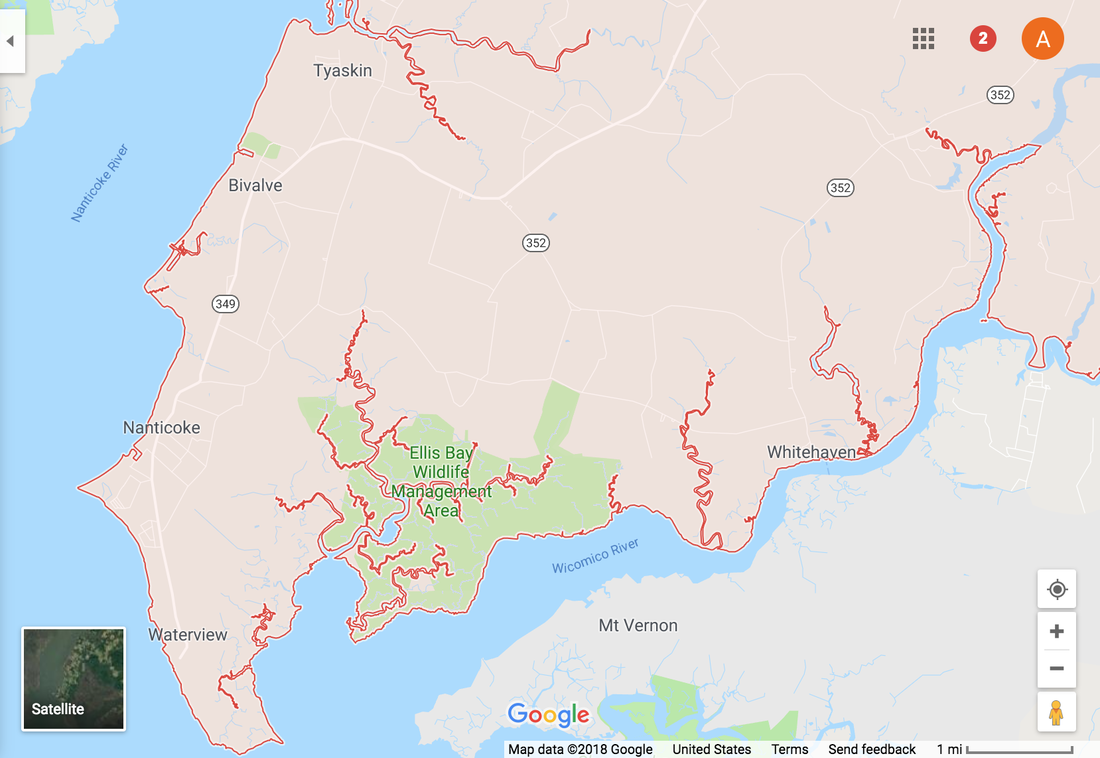
Map of the southwest portion of Wicomico county: This area is the most vulnerable to the effects of climate change. |
BOTTOMLAND HARDWOOD SWAMPS
Although the Atlantic White Cedar swamp forests were once common along the Nanticoke River, they now represent one of the rarest hardwood swamp ecosystems on the eastern shore. Underneath those trees grows sphagnum moss, and in this wet, soft spongy environment grows a host of orchids and other herbaceous species. On the other side of the county, Bald Cypress swamps line the Pocomoke River. Both the Atlantic White Cedar and Bald Cypress are naturally found in what is called sweet-water which is very fresh, clean and clear. These swamps are important for a range of animal species, including the endangered spotted turtle. As the freshwater lens gets pushed further upstream by the intruding saltwater, these rare ecosystems will transition to salt marsh. Hopefully, these magnificent ecosystems find open habitat to the north, and can migrate faster than the pace of sea level rise [1].
TIDAL WETLANDS
Tidal wetlands are also at risk of sea level rise along the waterways of Wicomico County. As the water rises, marshlands turn to open water as they are swallowed by the sea. Smooth cordgrass is an example of one important brackish plant that will not be able to tolerate rising sea levels. As it disappears, crabs, birds, and small mammals will lose their habitat and disappear as well. Habitat will also be lost for waterfowl and for endangered coastal birds such as the Saltmarsh Sparrow [2].
UPLAND FORESTS
Most of Wicomico's land is covered with dry, upland forests, where species like red oak and wild lupine abide. Currently, the types of upland forests that can be found in Wicomico County are pure pine forests, a few mixed hardwood forests, and mixed hardwood-pine and pine-hardwood forests. Loblolly pines are the most prominent feature of upland forest due to the monetary values associated with their propagation. Wicomico's forests support Maryland's largest hub of migratory songbirds along with other unique and endangered species such as the Delmarva Fox Squirrel and the Northern Pine Snake. Variable temperatures and intruding water from climate change will affect forested ecosystems by altering migratory bird patterns, the timing of seasonal plant and insect hatches, and will determine which species colonize open niche spaces once threatened species, like the green ash, have been eradicated [3].
Botanically, the latitude at which we sit is very unique because we are blessed with a mix of northern and southern species. As the climate warms, this latitudinal position will shift northward, and Wicomico will be left predominately with southern species. Furthermore, the expanding tidal areas will favor those species that are more salt tolerant [1].
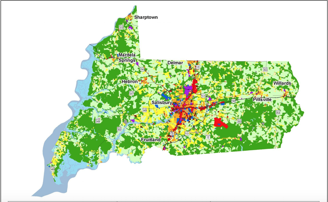
Wicomico County Land-Use
The following map from the Maryland Department of Planning (2010) reveals the different types of land cover across Wicomico County's 240,379 acres. Though tidal wetlands are a unique feature of Wicomico County's western perimeter, they only account for 14,259 acres of county land. Most of Wicomico is actually covered by forest (100,926 acres). Agriculture is the second largest category of land cover in the county. Its 78,838 acres are painted with row crops such as corn and soy. The remaining 46,057 acres are developed for commercial, industrial, and residential use [4].
|
Wicomico County Land-Use Source: Maryland Department of Planning, 2010 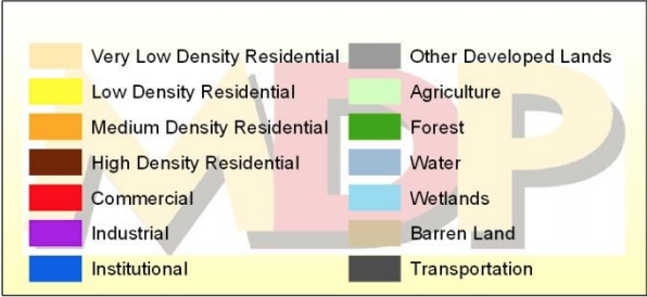
Maryland Department of Planning. (2010). Wicomico County. Retrieved from http://planning.maryland.gov
|
The Nature Conservancy Map
This map shows the Wetipquin Creek branching off the Nanticoke River, just above the town of Tyaskin. The green areas along the creek reveal that the waterway is rather resilient to the effects of sea level rise. However, the red coloration reveals that much of the inland areas will be underwater by the time the sea level rises 6 feet (dark orange). This is projected to occur within the next 80 - 130 years. As you can see, the town of Tyaskin will flood along with much of the surrounding agricultural land.
Map produced in 2018 by M. Canick, The Nature Conservancy- from publicly available data
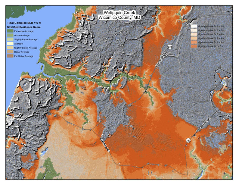
This LiDAR image map shows available migration space (gray) based on different levels of sea-level rise (red-orange) for the lower portion of the Nanticoke River. This map focuses on the southwest portion of the county because it is the area most susceptible to the damages of climate change. Sand ridges called xeric dunes (gray lines) were formed along the river's edge as a result of glacier activity from the last ice age. Over hundreds of years, the river continues to deposit sediments along its shore, building up the land along the river. The inland portions on the map are largely farmed for pine trees, and as you can see, this land is not much higher than the tidal wetlands along the shore (shown in green). However, it is kept dry enough for all the pines by virtue of the xeric dunes. Nonetheless, should the sea level rise six feet, most of this land will be underwater, and the pine plantations and agricultural land situated inland at these low levels will be negatively impacted [1].
References
- Personal communication, Joe Fehrer, Coastal and Lower Shore Project Manager for The Nature Conservancy, 4 April 2018, Furnace Town Visitor Center.
- National Park Service. (n.d.) Tidal Wetlands. Retrieved from https://www.nps.gov/subjects/wetlands/tidal.htm
- Maryland Forest Service. Maryland Department of Natural Resources. (2007). Sustainable Forest Management Plan for Chesapeake Forest Lands: Sustainable Forests for People and the Bay (Report No. 11). Sustainable Forestry Initiative. Retrieved from http://dnr.maryland.gov/forests/Documents/chesapeake/CF-SFMP_2018.pdf
- Maryland Department of Planning. (2010). Wicomico County. Retrieved from http://planning.maryland.gov/Documents/OurProducts/landuse/Wicomico.pdf
