
THE WICOMICO AND NANTICOKE RIVER are experiencing effects from erosion, subsidence and sea level rise. Although these three processes are extremely slow and are not directly noticeable, changes over time can be dramatic.
PROJECTIONS OF SEA LEVL RISE in the Chesapeake Bay are 2 feet by 2050 and 4 feet by 2100. The effects of climate change are in the near future. Wicomico County will lose an equivalent of 15,920 football fields (21,015 acres) of land by 2050, or a total loss of 19,675 football fields (25,971 acres)of land by 2100(1). That's more than 10% of total land in Wicomico County.
PROJECTIONS OF SEA LEVL RISE in the Chesapeake Bay are 2 feet by 2050 and 4 feet by 2100. The effects of climate change are in the near future. Wicomico County will lose an equivalent of 15,920 football fields (21,015 acres) of land by 2050, or a total loss of 19,675 football fields (25,971 acres)of land by 2100(1). That's more than 10% of total land in Wicomico County.
|
EROSION is the gradual loss of land from wind or water. |
SEA LEVEL RISE is when there is an increase of water in the ocean due to the melting of glaciers. |
SUBSIDENCE is a geological process where the land is sinking or settling to a lower level (2). |
CLICK through the tabs below to see how different areas along the Wicomico and Nanticoke Rivers have been affected and will be affected in the future by sea level rise!
|
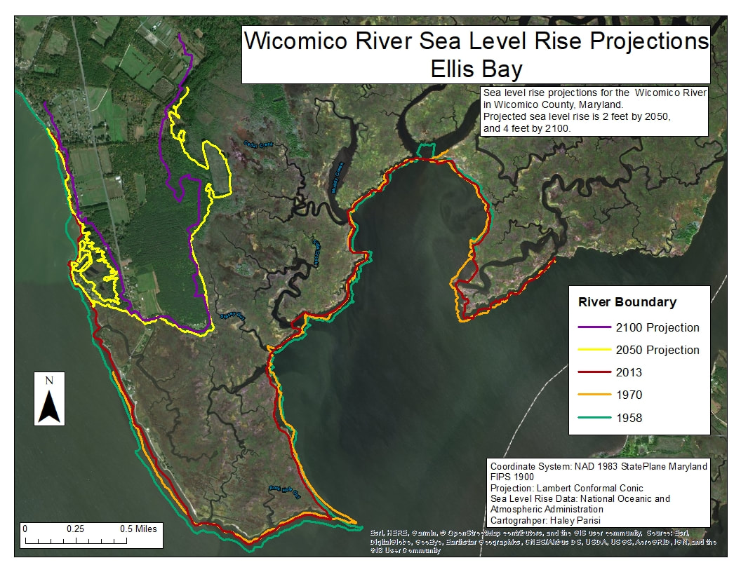
Ellis Bay is a tidal wetland located at the mouth of the Wicomico River which is a well used area for hunting and fishing. While sea level rise has not affected this area much from 1958 to today, the future projections of sea level rise for 2050 and 2100 show how significant the land loss will be. The mouth of the Wicomico will become much larger than it is now. This wetland harbors habitat for the Saltmarsh Sparrow, waterfowl, and Smooth Cordgrass but, if the sea levels continue to rise, the habitat will be lost.
|
|
|
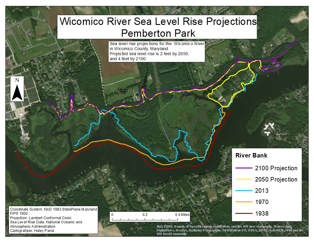
Pemberton Park is located on the Wicomico River in Salisbury. Pemberton Park is home to many recreational trails as well as a tidal wetland, shown in the map. The wetland has been receding, and projections for 2050 and 2100 suggest that all of the wetland will be lost, which will then widen this section of the Wicomico River. Pemberton Park is home to many native plant species, including Smooth Cordgrass as well as waterfowl species like the wood duck.
|
|
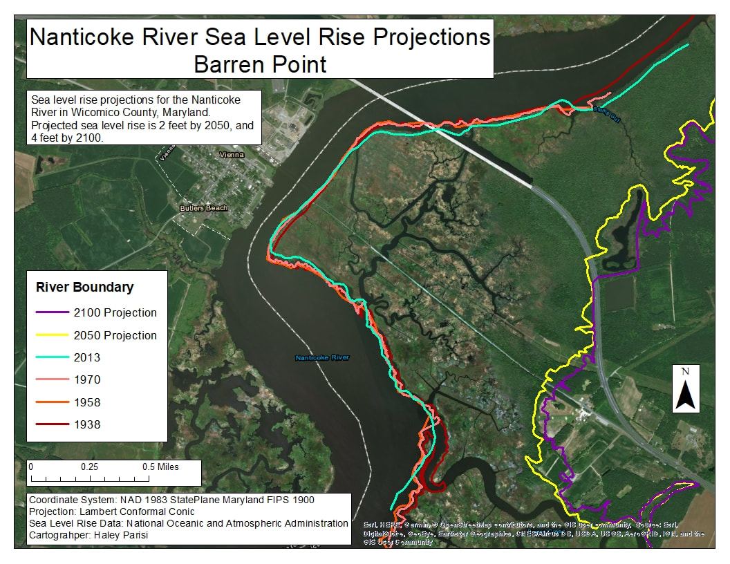
Barren Creek is located on the Nanticoke River in Mardela Springs. This area is a tidal wetland area, and is home to many native plant species as well as migratory waterfowl. As the map to the right shows, this part of the river has not seen any significant impacts from sea level rise yet. Future projections show a major loss of the wetland as well as homes in Mardela Springs. Not only will the wetland be affected, but infrastructure as well.
|
|
|
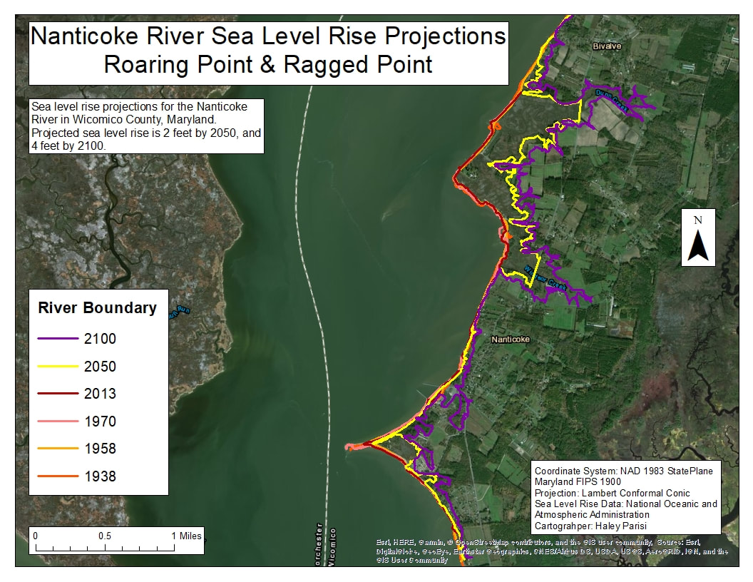
Roaring Point and Ragged Point are located at the mouth of the Nanticoke River. Roaring Point has recreational value, as it used as a campsite as well as kayaking and other activities. There has not been any significant impacts from sea level rise thus far, but the map to the left shows Ragged Point effects being much more sizable than Roaring Point. |
|
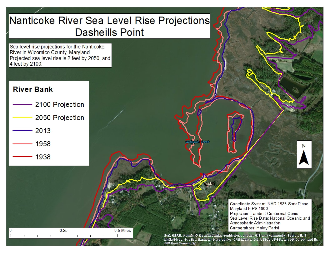
Dasheills Point is located on the Nanticoke River in Wetipquin Creek. As you can see from the map to the right, Dasheills Point has lost a great amount of land since 1938, and the rising seas will only further reduce land mass as time goes on. Not only will the wetlands of Wetipquin be affected, but the town of Wetipqiun will have to prepare for a loss of infrastructure. |
|
The Chesapeake Bay tributaries in Wicomico County (Wicomico and Nanticoke River) both have areas that are extremely vulnerable to sea level rise, increasing risk for the infrastructure around the rivers.
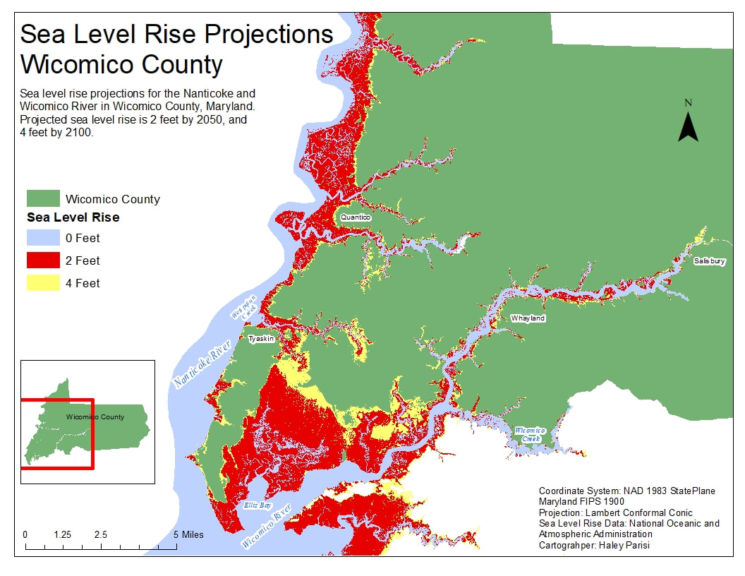
Below is a map that shows future projections for sea level rise in the Nanticoke and Wicomico River in Wicomico County. The blue area labeled 0 feet is the approximate water levels for today. Future projections of the sea level for 2 feet by 2100 is represented in red, and 4 feet by 2050 is represented by yellow. As you can see, as the sea level rises 2 and 4 feet, a majority of land will be lost, widening the mouth of the Wicomico as well as widening the Nanticoke River near the town of Quantico.
Below is a map that shows future projections for sea level rise in the Nanticoke and Wicomico River in Wicomico County. The blue area labeled 0 feet is the approximate water levels for today. Future projections of the sea level for 2 feet by 2100 is represented in red, and 4 feet by 2050 is represented by yellow. As you can see, as the sea level rises 2 and 4 feet, a majority of land will be lost, widening the mouth of the Wicomico as well as widening the Nanticoke River near the town of Quantico.
Click the buttons below to learn more about climate change impacts on the land, water and climate of Wicomico County.
References
1. Land loss due to sea level rise projections were computed using NOAA sea level rise data from https://coast.noaa.gov/slrdata/ by using ArcGIS. Calculations were made by Haley Parisi.
2. MADE CLEAR. (n.d.). Retrieved from http://madeclear.thinkport.org/#sea-level-rise.html
Header photo: Chesapeake Bay Program; Flickr.com
