
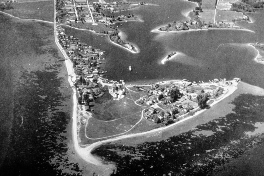
The Eastern Shore is extremely vulnerable to the effects of climate change. Sea level rise and erosion are detrimental because of the Eastern Shore's low-lying and flat land. The Eastern Shore has minimal slopes, so the rising sea will continue onto the land and destroy agricultural, commercial or residential areas. The Eastern Shore is also affected by climate change by the changing and increasing severity of weather and storms.
|
While sea level rise is the main focus of mitigation efforts in Delmarva, in reality there are two forces working against us. In the 20th century, the sea level has increased by one foot in Maryland, but sea level rise only accounts for half (six inches) of this rise in sea level. The remaining six inches are a result of the land surface slowly sinking since the end of the last Ice Age 20,000 years ago.
Chesapeake Bay Foundation; Flickr.com
|
During the last Ice Age, one giant glacier covered all of Canada and much of the northern United States, reaching as far as southern New York before finally retreating. Because of the immense pressure of the glacier, the land surface underneath was forced downwards into the ocean, while the land area just to the south of the glacier (including Maryland) was driven upwards, decreasing the average sea level. Today, the land is still trying to rebound (return to its original elevation prior to the glacier's movement) from this event; much of the land that was previously under the glacier is now rising back up, and the land surface that was driven upward is now sinking back down, resulting in the issues we see today.
|
Timeline:
20,000 years ago: (end of the last Ice Age): The climate began to warm and the glacier began its retreat.
8,000 years ago: The Chesapeake Bay is formed as the lower Susquehanna River valley is flooded by sea level rise.
5,000 years ago: Sea levels remained relatively constant but the land beneath the Bay continued to sink, resulting in the formation we see today.
20th Century: Sea levels in the Chesapeake Bay, "rose at a rate of about 3.5 mm/year, indicating local rate of subsidence was 1.7 mm/year or roughly half of a foot per century" (1). When combined with the sinking land surface, sea level rise is a real concern for Delmarva (Delaware, Maryland, and Virginia).
20,000 years ago: (end of the last Ice Age): The climate began to warm and the glacier began its retreat.
- At this time, the shoreline was more than 80 miles east of where it is today.
8,000 years ago: The Chesapeake Bay is formed as the lower Susquehanna River valley is flooded by sea level rise.
- Sea level rise during this period was roughly 16 mm (0.625 in) per year as a result of rapidly melting glaciers (1).
5,000 years ago: Sea levels remained relatively constant but the land beneath the Bay continued to sink, resulting in the formation we see today.
20th Century: Sea levels in the Chesapeake Bay, "rose at a rate of about 3.5 mm/year, indicating local rate of subsidence was 1.7 mm/year or roughly half of a foot per century" (1). When combined with the sinking land surface, sea level rise is a real concern for Delmarva (Delaware, Maryland, and Virginia).
- 1961-1993: global mean sea level rose at a rate of 1.8 mm per year, totaling 57.6 mm or just over 2 inches in a span of 32 years (without the effects of subsidence)
Sea-level rise is a causal force which influences the on-going coastal processes that drive erosion, in turn making coastal areas ever more vulnerable to both chronic erosion and episodic storm events (2).
Below is a video by the Maryland Sea Grant that discusses future sea level rise projections in Maryland.
|
As the climate continues to evolve in Wicomico County, very few will ever notice the overall changes. We grow accustomed to the weather we see throughout the year and only really stop to think about changes to our climate when the extreme heat or cold hit.
Although climate predictions for the future call for a warming in temperatures, climate change leads to not only an increase in the average air temperature over time, but is associated with much greater variability in temperature. The extreme weather is not just limited to heat: In the winters of 2014 and 2015, we had record cold temperatures and half of the largest snowstorms on record in the region have occurred since 2003. This extreme winter weather has caused some doubt about climate change, although 2016 was the warmest year ever recorded. |
Our climate has already warmed over 2°F in the past 20 years, a trend that will continue into the future if we don't limit our carbon emissions. Predictions have summer temperatures rising as much as 9°F with more frequent intense rainfall events mixed with summer droughts by 2100. |
Below is a graph that explains the lowest temperature each year in Salisbury from 1970 to 2017. "Even though extreme cold can still happen in winter, as was seen earlier this year in much of the country, the frequency and intensity of extreme cold is declining as the world warms from the increase in greenhouse gases" (3).
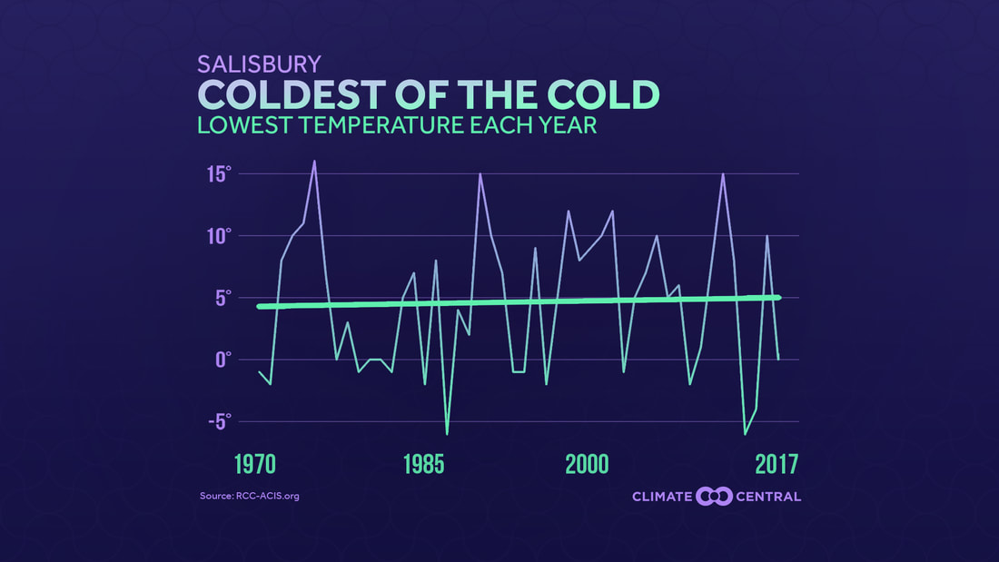
"While the decrease in cold may sound good on a cold winter day, that warming comes with consequences for farming, recreation, economy, and nature itself. Fruit trees, which need to become dormant over the winter to bloom in the spring, may produce smaller yields. Winter-based activities in colder climates, like skiing and snowmobiling will become less prevalent, and the tourist economies that support them may struggle. More disease-carrying insects, like ticks and mosquitoes will survive through a milder winter" (3).
Climate change is ravaging Dorchester County:
An eerie indication of Wicomico County's future...
|
Rick Abend, president of "The Friends of Blackwater National Wildlife Refuge" in Dorchester County, has noticed the impacts of climate change on the refuge's property. In fact, he mentioned that the Refuge partnered with the Audubon Society, Conservation Fund, Maryland DNR, U.S. Geological Survey, and the National Fish & Wildlife Service to undertake a thirty-acre project to turn "low marsh" habitat into "high marsh" habitat. Since high marsh habitat supports different types of vegetation, its resiliency against rising tides and severe storms is improved, and the marshes will last longer. This project was accomplished by dredging the Blackwater River to obtain mud that could then be sprayed across the fields. This would theoretically raise the land enough to allow vegetation to reestablish itself. Mr. Abend noted that the film, High Tide in Dorchester, incorporated the Refuge’s biologist, Matt Whitbeck, in a segment as he was spraying mud over this thirty-acre plot of land. The Refuge is constantly looking to purchase upland property so they can migrate as the marsh encroaches and becomes open water. According to Mr. Abend's research, Blackwater has already lost between 5,000 and 8,000 acres of former marsh habitat. There is not much they can do about land subsidence and sea level rise, but they are trying to “delay the inevitable”—although, as Rick pointed out, the film High Tide in Dorchester claims the future is already here [4].
|
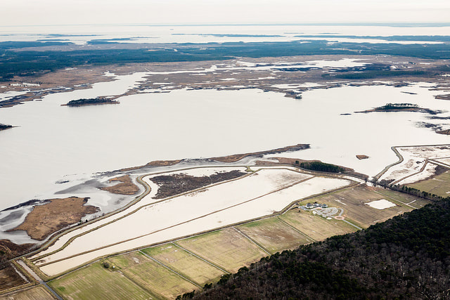
Photo by The Chesapeake Bay Program, flickr
In the photo above, one can view the series of manmade dikes in the Blackwater River, parallel to the shore of the Visitor Center, that were built "way before everyone was talking about sea level rise." Initially, they were created to allow better waterfowl habitat management and to enhance public viewing experiences. However, now the dikes double as water level regulators, keeping salt out of the impoundments during extreme high tide events [4]. |
However, sea level rise is affecting not only farmland, woodland, and marshes, says Mr. Abend. The city of Cambridge, as well as many other small towns in the southern portion of the county, are severely affected by flooding during storm events, or even just by abnormal high tides [4]. As the sea continue to rise and Dorchester County begins to disappear, we are sure to see these same problems spread to Wicomico County.
Check out the Climate Time Machine by NASA to find out how some of Earth's key climate indicators including global temperature, sea level, and CO2 are changing over time!
References
- Boesch, D. F., Dawson, F. W., Summers, R. M., Boicourt, W. C., Busalacchi, A. J., Cahoon, D. R., . . . Welty, C. (2008, July). Comprehensive Assessment of Climate Change Impacts in Maryland. Retrieved May 7, 2018, from http://www.mde.state.md.us/programs/Air/ClimateChange/Documents/FINAL-Chapt 2 Impacts_web.pdf
- Comprehensive Strategy for Reducing Maryland's Vulnerability to Climate Change. (2008, August). Retrieved May 7, 2018, from http://dnr.maryland.gov/ccs/Publication/Comprehensive_Strategy.pdf
- The Future of Extreme Cold in a Warming World. (2018, January 24). Retrieved from http://www.climatecentral.org/gallery/maps/the-future-of-extreme-cold-in-a-warming-world
- Personal communication, Rick Abend, president of The Friends of Blackwater National Wildlife Refuge, 28 March 2018, Blackwater National Wildlife Refuge Visitor Center.
