
What will Salisbury look like by 2100?
In this section, we will look at the specific potential risk of homes that could be underwater at the end of this century. The Salisbury Metropolitan area is expected to have the 7th most homes in the United States destroyed by rising seas. Besides just examining future data, we will also briefly look over the damage Wicomico county has already faced when coping with the devastation of storm surge and increased levels of intense precipitation.
Is your home safe now? What about 100 years from now? Read below to find out.
Is your home safe now? What about 100 years from now? Read below to find out.
|
Salisbury on a National Scale
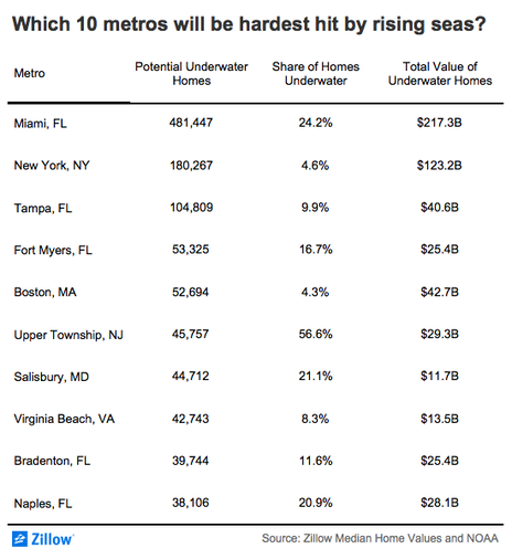
Of the changes that occur due to sea level rise, housing and infrastructure remain at the highest level of concern. Despite the city of Salisbury being surrounded by several rivers and ponds, while also being a low-lying landscape, urban development continues to grow. A recent study by online real estate company, Zillow, confirms that 1.9 million homes in the United States will be underwater within the end of this century if the oceans were to rise by six feet [3]. Unfortunately, the Salisbury metropolitan area was named one of the top 10 metro areas predicted to be hardest hit by rising seas [3]. With a potential to lose up to 44,712 homes, how much could other nearby areas lose? |
Projected Housing Loss
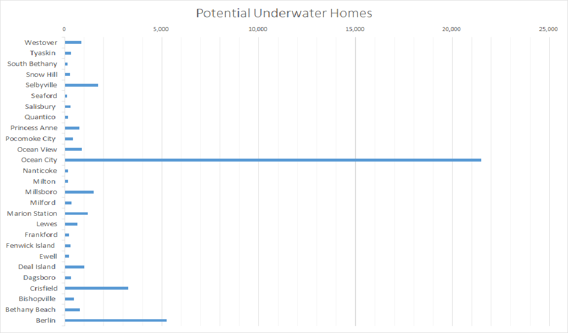
By 2100, the Salisbury Metropolitan area is predicted to lose 21% of its homes, for a total value of $11.8 billion [3]. As seen on the graph below, Ocean City is most affected by rising seas. Zillow confirmed that Ocean City is projected to lose more homes than any other ZIP code in the United States - 22,384 properties worth a combined $6.2 billion [3]. In Wicomico county, Tyaskin will lose the most homes.
By 2100, the Salisbury Metropolitan area is predicted to lose 21% of its homes, for a total value of $11.8 billion [3]. As seen on the graph below, Ocean City is most affected by rising seas. Zillow confirmed that Ocean City is projected to lose more homes than any other ZIP code in the United States - 22,384 properties worth a combined $6.2 billion [3]. In Wicomico county, Tyaskin will lose the most homes.
|
What is included in the Salisbury Metropolitan area?
The Salisbury Metropolitan Area is a census designation and includes Wicomico, Somerset, Worcester, and Sussex counties. Cities and towns include: Berlin, Bethany Beach, Bishopsville, Crisfield, Dagsboro, Deal Island, Ewell, Fenwick Island, Frankford, Lewes, Marion Station, Milford, Millsboro, Milton, Nanticoke, Ocean City, Ocean View, Pocomoke City, Princess Anne, Quantico, Salisbury, Seaford, Selbyville, Snow Hill, South Bethany, Tyaskin, and Westover. |
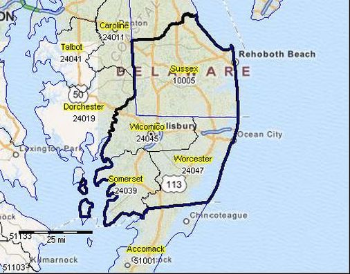
ProximityOne Situation & Outlook Report - Salisbury, MD-DE Metropolitan Statistical Area
|
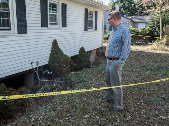 Grady McGrew, of Salisbury, observes the damaged foundation of his house caused by heavy storms on Sept. 29. (Photo: by Ralph Musthaler)
The Damage We've Seen So Far
Losing several homes in the Salisbury area in one major storm seems impossible, but some homeowners have already discovered the devastating effects heavy rain, storm surge, and sea level rise can have on their homes.
A Devastating Storm
In September of 2016, Salisbury was hit with a record breaking storm, accumulating 7 inches of rainfall overnight. Almost 70 homes were condemned, low-lying roads were flooded and sinkholes developed on three streets [2]. Mayor of Salisbury, Jake Day, stated the storm was "stronger and bigger than most of the hurricanes we get" [2]. The severe storm also "threatened the stability of the Morris Mill dam and forced the evacuations of the Canal Woods condominium complex and 13 houses on Delaware Avenue," making the storm one of the most devastating flooding events since Hurricane Sandy [2]. With walls, foundations, and roads that have stood for decades being destroyed in a matter of a few hours of heavy rain, the more helpless homeowners feel. However, some homeowners in the greater Chesapeake Bay region have began the fight against rising waters.
Will your home be underwater?
|
|
To read more about climate change impacts on society, check out each of the links below!
References
- Nosakhare, Osarodion K., et al. "Land Use-Land Cover Changes in the Lower Eastern Shore Watersheds and Coastal Bays of Maryland: 1986-2006." Journal of Coastal Research, vol. 28, no. 1A, Jan 2012 Supplement, pp. 54-62. EBSCOhost, doi:10.2112/JCOASTRES-D-09-00074.1.
- Holland, Liz. “'1,000-Year Storm' Ruined Houses, Lives in Salisbury.” Delmarva Daily Times, The Daily Times, 1 Dec. 2016, www.delmarvanow.com/story/news/local/maryland/2016/12/01/flood-salisbury-recovery/94611906/
- Bretz, Lauren. “Climate Change and Homes: Who Would Lose the Most to a Rising Tide?” Zillow Research, 17 Jan. 2018, www.zillow.com/research/climate-change-underwater-homes-2-16928/
- Middleton, Leslie. “Bay Journal.” Bay Journal RSS, 22 Jan. 2015, www.bayjournal.com/article/living_shorelines_rising_up_to_offset_effects_of_higher_sea_levels
- Metro-Map Figure: “Salisbury, MD-DE MSA Situation & Outlook Report.” Click for Info, proximityone.com/metros/2013/cbsa41540.htm.
